Tal Tal Heights
Tal Tal Heights is a location in Link's Awakening.[1]
Features and Overview
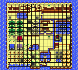
Tal Tal Heights are located south of the Tal Tal Mountain Range. It also borders Goponga Swamp to the west, and Tabahl Wasteland, Kanalet Castle, and the Rapids Ride to the south. Moblins and Tektites are the predominant enemies in this region, though Like Likes and Octoroks also appear. The region is divided into a western area, which is dry, and the eastern area, which is home to an extensive river. The two regions are connected by a narrow isthmus blocked by a boulder.
The Moblin Cave, a mini-dungeon, is in the eastern part of the region. In Link's Awakening DX, the Photo Shop is also here. The eastern area as a whole is mostly empty, although the base of Mount Tamaranch can be found here as well.
Eastern Tal Tal Heights is home to the fourth dungeon, Angler's Tunnel, which is behind a waterfall in the western area of the region. Because the Flippers are located in the dungeon itself, it cannot initially be accessed from the Tal Tal Heights, and require Link to jump off of a cliff in the Tal Tal Mountain Range. There are two flooded caves near the Angler's Tunnel, one of which is home to Manbo, who teaches Link Manbo's Mambo; the other has a Piece of Heart underwater, and can also be accessed by falling down a hole in the Tal Tal Mountain Range. The very eastern section of Tal Tal Heights contains an island which is the starting point for the Rapids Ride. A cave connects this island to the end of the Ride in Face Shrine. This area also contains a warp hole.
Trivia
- In Breath of the Wild, Tal Tal Peak and Southern Tal Tal Peak are both named after Tal Tal Heights and the Tal Tal Mountain Range.[2]
Nomenclature
| Language | Names | Meanings |
|---|---|---|
ChineseSI | 达达高原 (Dádá gāoyuán) (LANS)[5] | |
FrenchCA | Plateau Tartare (LANS) | Tartar Plateau |
FrenchEU | Plateau Tartare (LANS) | Tartar Plateau |
German | Taltal-Höhen (LANS) | Taltal Heights |
Italian |
|
|
SpanishEU | Meseta de Tal Tal (LANS)[4] | Tal Tal Plateau |
| This table was generated using translation pages. To request an addition, please contact a staff member with a reference. | ||
References
- ↑ Encyclopedia, Dark Horse Books, pg. 234(LA)
- ↑ The Legend of Zelda: Breath of the Wild—The Complete Official Guide, Piggyback Interactive Limited, pg. 351
- ↑ Enciclopedia di Hyrule, Magazzini Salani, pg. 234
- ↑ "Meseta de Tal Tal" — System (Link's Awakening for Nintendo Switch, European Spanish localization)
- ↑ "达达高原" — Map (Link's Awakening for Nintendo Switch)
| Regions in Link's Awakening |
|---|
 |
| Click on an area |